Plan an acoustic-trawl survey.
DefineSurveyPlan(
  processData,
  UseProcessData = FALSE,
  StratumPolygon,
  DefinitionMethod = c("Parallel", "ZigZagRectangularEnclosure", "ZigZagEqualSpacing",
    "ResourceFile"),
  FileName = character(),
  StratumNames = character(),
  Bearing = c("Along", "Across", "AlongReversed", "AcrossReversed"),
  BearingAngle = numeric(),
  Retour = FALSE,
  SurveyTime = numeric(),
  SurveyDistance = numeric(),
  SurveySpeed = numeric(),
  EqualEffort = TRUE,
  OrderAllToursFirst = FALSE,
  Seed = numeric(),
  Margin = 0.1
)
Arguments
- processData
The current data produced by a previous instance of the function.
- UseProcessData
Logical: If TRUE use the existing function output in the process.
- StratumPolygon
The
StratumPolygonprocess data.- DefinitionMethod
Character: A string naming the method to use, either "ResourceFile" for reading the survey plan from a file, or a string naming the type of survey design to create (see details).
- FileName
The path to a resource file from which to read the SurveyPlan process data, in the case that
DefinitionMethodis "ResourceFile".- StratumNames
Character: The names of the strata to include in the survey plan. Defaults to all strata.
- Bearing
Character: A string indicating the survey bearing (direction) of each . See Details for options.
- BearingAngle
Numeric: In the case that
Bearing = "Angle",BearingAnglegives the angle of the survey bearing (direction) counter clockwise from north in degrees.- Retour
Logical: If TRUE the survey plan will be doubled by a retour.
- SurveyTime, SurveyDistance
The time/traveled distance to spend in each stratum including transport between segments, given in hours/nautical miles, where
SurveyDistancehas precedence overSurveyTime. The vector is repeated to have length equal to the number of strata specified instrata, so that only one value is given, this is the hours/nmi in all strata. Optionally, if a single value is enclosed in a list, it is regarded as the total hours/nmi for the entire survey. In this case selecting only a subset of the strata usingstratawill increase the effort in the selected strata.- SurveySpeed
Numeric: The time to be used for each stratum. Note that the resulting accumulated time may not be exactly equal to
SurveyTime.- EqualEffort
Character: A string naming the method to use. See Details for options.
- OrderAllToursFirst
Logical: If TRUE order all tours first and all retours last, which can be useful for multiple Strata in the same survey direction (e.g. a row of strata along a coast line).
- Seed
Numeric: The seed to use when drawing the random starting point.
- Margin
Numeric: The margin to use when iterating to fit the survey plan to the desired survey distance (including transport between segments). The function iterates until the survey distance is within
Marginof the desired survey distance, and jumps out of the iteration after 100 tries or if not converging.
Value
An object of StoX data type SurveyPlan.
Details
The DefineSurveyPlan function generates the survey plan (transect lines) in a Cartesian coordinate system, and transforms the positions to the geographical coordinate system (longitude, latitude) using the azimuthal equal distance projection, which ensures that distances are preserved in the transformation.
The following types are implemented throught DefinitionMethod:
- "Parallel"
"Parallel transects"
- "ZigZagEqualSpacing"
"Equal space zigzag sampler, Strindberg and Buckland (2004). End transects are generated different from Strindberg and Buckland (2004), by mirroring the last transect around the line perpendicular to the survey direction passing through the last intersection point between the stratum border and the parallel lines used to generate the transects."
- "ZigZagRectangularEnclosure"
"Rectangular enclosure zigzag sampler, Harbitz (2019)"
References
Strindberg, S., & Buckland, S. T. (2004). Zigzag survey designs in line transect sampling. Journal of Agricultural, Biological, and Environmental Statistics, 9, 443-461.
Harbitz, A. (2019). A zigzag survey design for continuous transect sampling with guaranteed equal coverage probability. Fisheries Research, 213, 151-159.
Examples
library(ggplot2)
stratumFile <- system.file(
"testresources",
"strata_sandeel_2020_firstCoverage.wkt", package = "RstoxBase"
)
stratumPolygon<- DefineStratumPolygon(
DefinitionMethod = "ResourceFile",
FileName = stratumFile
)
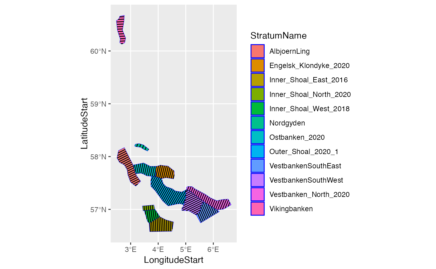
# Harbitz zigzag survey design along each stratum:
surveyPlanZZ_Along <- DefineSurveyPlan(
DefinitionMethod = "ZigZagRectangularEnclosure",
StratumPolygon = stratumPolygon,
SurveyTime = 200,
SurveySpeed = 10,
Seed = 1,
Bearing = "Along"
)
#> StoX: SurveyPlan for Stratum AlbjoernLing...
#> StoX: numIter: 1
#> StoX: numIter: 2
#> StoX: SurveyPlan for Stratum Engelsk_Klondyke_2020...
#> StoX: numIter: 1
#> StoX: numIter: 2
#> StoX: SurveyPlan for Stratum Inner_Shoal_East_2016...
#> StoX: SurveyPlan for Stratum Inner_Shoal_North_2020...
#> StoX: numIter: 1
#> StoX: numIter: 2
#> StoX: SurveyPlan for Stratum Inner_Shoal_West_2018...
#> StoX: numIter: 1
#> StoX: numIter: 2
#> StoX: SurveyPlan for Stratum Nordgyden...
#> StoX: numIter: 1
#> StoX: numIter: 2
#> StoX: SurveyPlan for Stratum Ostbanken_2020...
#> StoX: numIter: 1
#> StoX: numIter: 2
#> StoX: SurveyPlan for Stratum Outer_Shoal_2020_1...
#> StoX: SurveyPlan for Stratum Vestbanken_North_2020...
#> StoX: numIter: 1
#> StoX: numIter: 2
#> StoX: SurveyPlan for Stratum VestbankenSouthEast...
#> StoX: SurveyPlan for Stratum VestbankenSouthWest...
#> StoX: SurveyPlan for Stratum Vikingbanken...
#> StoX: numIter: 1
#> StoX: numIter: 2
# Plot the stratumPolygon with the segments
ggplot() +
geom_sf(data = stratumPolygon, aes(fill = StratumName), color = 'blue') +
geom_segment(
data = surveyPlanZZ_Along,
aes(x = LongitudeStart, y = LatitudeStart, xend = LongitudeEnd, yend = LatitudeEnd)
)
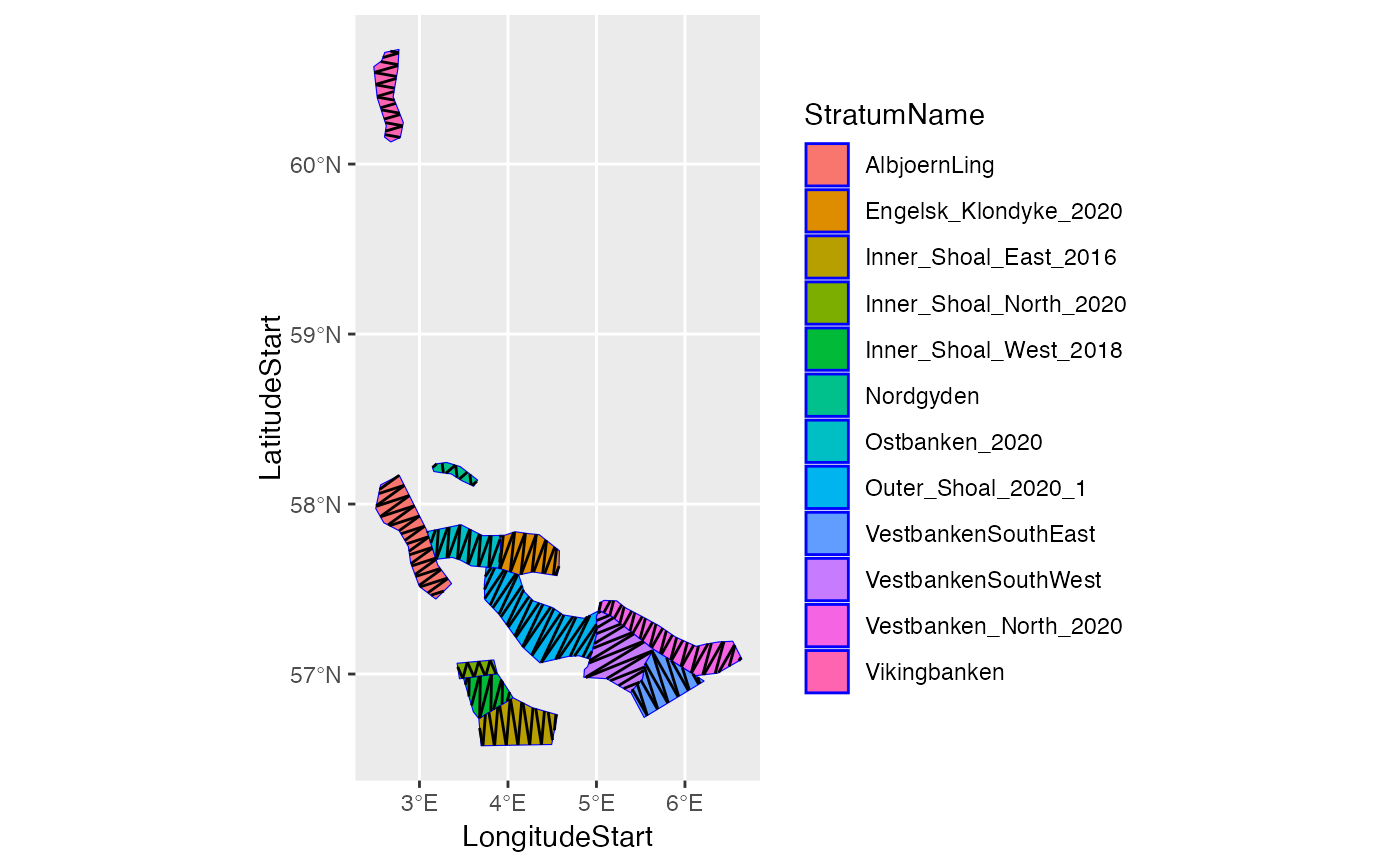 # Harbitz zigzag survey design across each stratum:
surveyPlanZZ_Across<- DefineSurveyPlan(
DefinitionMethod = "ZigZagRectangularEnclosure",
StratumPolygon = stratumPolygon,
SurveyTime = 200,
SurveySpeed = 10,
Seed = 1,
Bearing = "Across"
)
#> StoX: SurveyPlan for Stratum AlbjoernLing...
#> StoX: SurveyPlan for Stratum Engelsk_Klondyke_2020...
#> StoX: SurveyPlan for Stratum Inner_Shoal_East_2016...
#> StoX: SurveyPlan for Stratum Inner_Shoal_North_2020...
#> StoX: SurveyPlan for Stratum Inner_Shoal_West_2018...
#> StoX: numIter: 1
#> StoX: numIter: 2
#> StoX: SurveyPlan for Stratum Nordgyden...
#> StoX: numIter: 1
#> StoX: numIter: 2
#> StoX: numIter: 3
#> StoX: SurveyPlan for Stratum Ostbanken_2020...
#> StoX: SurveyPlan for Stratum Outer_Shoal_2020_1...
#> StoX: SurveyPlan for Stratum Vestbanken_North_2020...
#> StoX: SurveyPlan for Stratum VestbankenSouthEast...
#> StoX: SurveyPlan for Stratum VestbankenSouthWest...
#> StoX: SurveyPlan for Stratum Vikingbanken...
# Plot the stratumPolygon with the segments
ggplot() +
geom_sf(data = stratumPolygon, aes(fill = StratumName), color = 'blue') +
geom_segment(
data = surveyPlanZZ_Across,
aes(x = LongitudeStart, y = LatitudeStart, xend = LongitudeEnd, yend = LatitudeEnd)
)
# Harbitz zigzag survey design across each stratum:
surveyPlanZZ_Across<- DefineSurveyPlan(
DefinitionMethod = "ZigZagRectangularEnclosure",
StratumPolygon = stratumPolygon,
SurveyTime = 200,
SurveySpeed = 10,
Seed = 1,
Bearing = "Across"
)
#> StoX: SurveyPlan for Stratum AlbjoernLing...
#> StoX: SurveyPlan for Stratum Engelsk_Klondyke_2020...
#> StoX: SurveyPlan for Stratum Inner_Shoal_East_2016...
#> StoX: SurveyPlan for Stratum Inner_Shoal_North_2020...
#> StoX: SurveyPlan for Stratum Inner_Shoal_West_2018...
#> StoX: numIter: 1
#> StoX: numIter: 2
#> StoX: SurveyPlan for Stratum Nordgyden...
#> StoX: numIter: 1
#> StoX: numIter: 2
#> StoX: numIter: 3
#> StoX: SurveyPlan for Stratum Ostbanken_2020...
#> StoX: SurveyPlan for Stratum Outer_Shoal_2020_1...
#> StoX: SurveyPlan for Stratum Vestbanken_North_2020...
#> StoX: SurveyPlan for Stratum VestbankenSouthEast...
#> StoX: SurveyPlan for Stratum VestbankenSouthWest...
#> StoX: SurveyPlan for Stratum Vikingbanken...
# Plot the stratumPolygon with the segments
ggplot() +
geom_sf(data = stratumPolygon, aes(fill = StratumName), color = 'blue') +
geom_segment(
data = surveyPlanZZ_Across,
aes(x = LongitudeStart, y = LatitudeStart, xend = LongitudeEnd, yend = LatitudeEnd)
)
 # Parallel survey design across each stratum:
surveyPlanParallel_Across<- DefineSurveyPlan(
DefinitionMethod = "Parallel",
StratumPolygon = stratumPolygon,
SurveyTime = 200,
SurveySpeed = 10,
Seed = 1,
Bearing = "Along"
)
#> StoX: SurveyPlan for Stratum AlbjoernLing...
#> StoX: SurveyPlan for Stratum Engelsk_Klondyke_2020...
#> StoX: SurveyPlan for Stratum Inner_Shoal_East_2016...
#> StoX: SurveyPlan for Stratum Inner_Shoal_North_2020...
#> StoX: numIter: 1
#> StoX: numIter: 2
#> StoX: SurveyPlan for Stratum Inner_Shoal_West_2018...
#> StoX: SurveyPlan for Stratum Nordgyden...
#> StoX: numIter: 1
#> StoX: numIter: 2
#> StoX: SurveyPlan for Stratum Ostbanken_2020...
#> StoX: SurveyPlan for Stratum Outer_Shoal_2020_1...
#> StoX: SurveyPlan for Stratum Vestbanken_North_2020...
#> StoX: SurveyPlan for Stratum VestbankenSouthEast...
#> StoX: SurveyPlan for Stratum VestbankenSouthWest...
#> StoX: SurveyPlan for Stratum Vikingbanken...
# Plot the stratumPolygon with the segments
ggplot() +
geom_sf(data = stratumPolygon, aes(fill = StratumName), color = 'blue') +
geom_segment(
data = surveyPlanParallel_Across,
aes(x = LongitudeStart, y = LatitudeStart, xend = LongitudeEnd, yend = LatitudeEnd)
)
# Parallel survey design across each stratum:
surveyPlanParallel_Across<- DefineSurveyPlan(
DefinitionMethod = "Parallel",
StratumPolygon = stratumPolygon,
SurveyTime = 200,
SurveySpeed = 10,
Seed = 1,
Bearing = "Along"
)
#> StoX: SurveyPlan for Stratum AlbjoernLing...
#> StoX: SurveyPlan for Stratum Engelsk_Klondyke_2020...
#> StoX: SurveyPlan for Stratum Inner_Shoal_East_2016...
#> StoX: SurveyPlan for Stratum Inner_Shoal_North_2020...
#> StoX: numIter: 1
#> StoX: numIter: 2
#> StoX: SurveyPlan for Stratum Inner_Shoal_West_2018...
#> StoX: SurveyPlan for Stratum Nordgyden...
#> StoX: numIter: 1
#> StoX: numIter: 2
#> StoX: SurveyPlan for Stratum Ostbanken_2020...
#> StoX: SurveyPlan for Stratum Outer_Shoal_2020_1...
#> StoX: SurveyPlan for Stratum Vestbanken_North_2020...
#> StoX: SurveyPlan for Stratum VestbankenSouthEast...
#> StoX: SurveyPlan for Stratum VestbankenSouthWest...
#> StoX: SurveyPlan for Stratum Vikingbanken...
# Plot the stratumPolygon with the segments
ggplot() +
geom_sf(data = stratumPolygon, aes(fill = StratumName), color = 'blue') +
geom_segment(
data = surveyPlanParallel_Across,
aes(x = LongitudeStart, y = LatitudeStart, xend = LongitudeEnd, yend = LatitudeEnd)
)